


PPM Commander - GPS status

PPM Commander - GPS status介绍
Connect your external GPS device by USB or bluetooth. Route the GPS position as mock location provider to any navigation app on your phone or tablet.
Show GPS status data like position, height, accuracy, satellites, velocity, etc.
You can forward RTK correction data to your high accuracy external device. RTCM data is loaded from the internet by the internal NTRIP client.
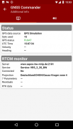
The app ist completely free with the exception of the NTRIP-RTCM feature. If you want to forward RTK data from your data provider (e.g. land surveying office) to the external GPS antenna, please license the app. You can fully test the NTRIP feature in advance within the 30 days trial period. You can view received RTCM message-types and coordinate-projection-parameters of the RTK data on the RTCM monitor page.
PPM Commander supports devices from ppm GmbH only, eg. ppm-10xx!
The PPM Commander can transform WGS84 coordinates into a local coordinate system like "Gauß-Krueger or UTM" for germany. Additionally you can set a fixed offset to the transformation for further improvement of the calculated local coordinate. If you allow mock locations in the developer options of your android device you can use the position of the external receiver in any application. The preferred way to process the external GPS position in other apps without using "mock locations" is implementing a simple ContentObserver. You can even get the transformed local coordinate and additional informations about the GPS status by using the app as content-provider.
By activating the "mocking" feature (get the position of your external GPS antenna into android) you can use this app for any other navigation-app or for geo-tagging.
Free features
+ GPS Status
+ Satellite list & Sky-Plot with subsystems like GPS, Glonass or Galileo
+ Coordinate-Transformation into local coordinate system
+ Mock location provider (e.g. use your external device for navigation)
+ Log all received NMEA data
You need a license for
+ RTK correction data over internet (NTRIP client)
+ RTCM monitor
+ Android "content provider" feature to access all status data
通过 USB或蓝牙连接外部GPS设备。将GPS位置作为模拟位置提供商路由到手机或平板电脑上的任何导航应用。
显示 GPS状态数据,如位置,高度,精度,卫星,速度等。
您可以将 RTK校正数据转发到高精度外部设备。 RTCM数据由内部NTRIP客户端从Internet加载。
该应用程序完全免费,但NTRIP-RTCM功能除外。如果您想将数据提供商(例如土地测量办公室)的RTK数据转发到外部GPS天线,请为该应用授予许可。您可以在30天试用期内提前全面测试NTRIP功能。您可以在RTCM监视器页面上查看RTK数据的接收RTCM消息类型和坐标投影参数。
PPM Commander仅支持ppm GmbH的设备,例如。 PPM-10XX!
PPM指挥官可以将WGS84坐标转换为德国的“Gauß-Krueger或UTM”等本地坐标系。此外,您可以为变换设置固定偏移量,以进一步改进计算的局部坐标。如果您在Android设备的开发人员选项中允许模拟位置,则可以在任何应用程序中使用外部接收器的位置。在不使用“模拟位置”的情况下处理其他应用程序中的外部GPS位置的首选方法是实现简单的ContentObserver。您甚至可以通过将应用程序用作内容提供者来获取有关GPS状态的变换后的本地坐标和其他信息。
通过激活“模拟”功能(将外部GPS天线的位置放入android),您可以将此应用程序用于任何其他导航应用程序或地理标记。
免费功能
+ GPS状态
+卫星列表和Sky-Plot以及GPS,Glonass或Galileo等子系统
+坐标 - 转换为局部坐标系
+模拟位置提供商(例如使用您的外部设备进行导航)
+记录所有收到的NMEA数据
您需要 的许可证
+互联网上的RTK校正数据(NTRIP客户端)
+ RTCM监视器
+ Android“内容提供商”功能可访问所有状态数据

PPM Commander - GPS status - APK信息
APK版本: 2.8.2.3程序包: de.pilablu.gnsscommanderPPM Commander - GPS status的最新版本
其他版本


同类应用

您可能还会喜欢……


